In the research project AccessibleMaps, we address a user-centered design approach where the target group is involved in every phase of the development process. By designing user-friendly and accessible applications, the human being as a user of technology moves more into the focus. In order to develop a better understanding of the target group as well as their goals and needs, various methods are used in usability research.
In the AccessibleMaps project, an extensive online survey was first conducted with people with blindness, visual impairment, and mobility impairment for this purpose. On the basis of this, personas were developed that reflect the needs and requirements of the target group in the form of fictional person descriptions. In addition, a “user journey map” has been derived that reflects possible interaction scenarios when using an application to support orientation in buildings.
List of Contents
Online Survey
At the beginning of 2020, an online survey was conducted with 136 participants with blindness, visual impairment and mobility impairment as part of the “AccessibleMaps” project. The aim of the study was to analyze the current practices of people of the target group when orienting themselves and finding their way in unfamiliar buildings. In addition to orientation strategies, information about challenges in orientation and the need for information about the accessibility of buildings were analyzed. In addition, the survey provides information about participants’ experiences with unfamiliar buildings, navigation applications, and maps. Requirements for maps and preferred map formats and types were also collected. The results of the survey form the basis for designing a target group-oriented and needs-based map application for buildings. As part of the project, requirements for the development of a mobile, digital map application as well as personas were derived from this.
Below you will find an overview of the results of the survey. A detailed description can be found in the attached report (German only).
Results of the Survey
Participants. A total of 136 people completed the questionnaire in its entirety. Among them were 34 persons with a mobility impairment, 64 persons with blindness, and 43 with a (severe) visual impairment. The participants were on average 45.5 years old (SD: 14.7). The majority of respondents were from German-speaking countries and were employed at the time of the survey.
Visits of Public Buildings. All three groups visit public buildings with a sometimes varying frequency, especially in relation to different types of buildings, which supports the need for aids for orientation in buildings. On average, shopping malls, airports and train stations, restaurants, and office buildings are visited most frequently.
Planning Behavior of the Respondents. Traveling to unfamiliar buildings is usually planned several days in advance by the majority of respondents. Most often, planning is done at home or in the office. The main reasons for not planning the trip in advance (13 percent) are the lack of availability of information and the lack of accessible materials.
Planning Materials. Overall, digital maps, a guide person or assistance, and descriptions are primarily used by many respondents for planning at home. For persons with blindness, a guide/assistance is very important in all phases of the trip. Photos, as well as printed maps, are also used by some respondents primarily for planning at home or in the office as a source of information. It is noteworthy that materials are used less frequently in the building itself.
Information Needs for Planning and Implementation. The data suggest that information needs for planning differ between respondents with blindness, visual impairment, and mobility impairment. While general building information, such as the address of the building, the room name of the destination, opening hours as well as the location of the main entrances are important, on-site in the building there is also a need for more concrete information such as the location of the staircases.
Wayfinding Strategies. Repeatedly asking for help to find a way appears to be one of the most frequent strategies of all three groups. While almost every third person with blindness also uses assistance, only about every tenth person with visual impairment or mobility impairment has the assistance. In contrast, respondents with blindness or a visual impairment, in particular, would prefer to have a map or textual description available more often. To find the exit in a building, most respondents remember the way there and use it again on the way back.
Challenges in Buildings. Barriers and challenges arise primarily because of the building structure (e.g., highly angled corridors, round walls, large glass fronts, doors that are too heavy) as well as the building features (e.g., missing signage, signage that is too small, low-contrast signage, poor lighting). Legible signs and good lighting, as well as guidance and guidance systems, can improve orientation.
Use of Indoor Maps. Only about a quarter of all participants had previous experience with indoor maps, with digital and printed maps being the most commonly used. The location where the maps have been used so far (at home, on the move, or in the building) varied, particularly among respondents with blindness, visual impairments, or mobility impairments. The data also reveal the lack of availability of indoor maps as a major reason why they have not been used previously. There is a desire to use indoor maps across all groups.
Personas
Personas are fictional people of the target group who have goals, needs, skills, and characteristics like real users. The persona’s challenges and current behavior are also described. Personas thus represent a major part of the future users. Different personas can therefore be developed for an application, each reflecting different perspectives and needs. Based on the personas, concrete usage scenarios are discussed in the further development process, which can be directly addressed by the later application.
The six personas listed below represent the addressed user groups of the research project AccessibleMaps. They are based on research findings from our online study, personal contacts, and interviews with people in the target group, as well as existing research findings from the literature. We developed two personas each for people with blindness, visual impairments, and people with mobility impairments to reflect the different needs.
Personas: Blind people
Alex, 35 years, blind
Confident, self-assured
I have a good sense of orientation, unfortunately I usually lack the necessary information to quickly find ways in unfamiliar buildings on my own.
Alex, 35 years, blind
About the person
Alex has been blind since childhood and visits unfamiliar buildings, such as hotels, restaurants, office buildings and shopping malls, both in private and professional contexts. Alex has a good orientation and is mostly on their own.
Since Alex frequently visits different buildings, it is important to quickly reach the destination. Alex has experience with haptic maps, primarily using them in the building or on the way there. Alex frequently uses navigation apps on their smartphone to find their way and always relies on the technical aids.
Experiences and Skills
- Braille Skills: high
- Orientation: good
- Maps: few
- Technology: high
Goals and Motivation
- Finding destinations in an unfamiliar building quickly and independently
- Getting up-to-date information about the building
- Using building maps to find their way independently
Assistive Technology
Alex uses a white cane and has attended mobility training. The smartphone often works as a tool for various services.
Behavior
- Plans a trip on the same day or the day before
- often uses the smartphone as a tool for outdoor navigation
- uses building features for orientation or asks when no other sources of information are available
- uses tactile overview maps if available
- prefers the fastest way to the destination
Challenges
- Quickly finding ways in unfamiliar buildings
- Getting access to digital maps
Useful features
- Getting information about physical barriers in buildings
- Getting information about fast routes in buildings
- Receiving tactile or 3D-printed maps for buildings
- Receiving auditory navigation instructions
- Fast routes through the building based on Alex´ capabilities
- Quick and easy operation of the smartphone application
- Adjustable speech speed of the output
- Accessible, digital you-are-here maps
Toni, 55 years, blind
Reluctant, uncertain
I have difficulties finding my way around buildings without assistance. Clear, tactile maps could help navigating more easily in a building or to find planned or already walked routes again.
Toni, 55 years, blind
About the person
Toni has been blind since childhood and has very good Braille skills. Whenever possible, Toni tries to explore the world tactilely. Toni visits office buildings, train stations, restaurants and shopping malls several times a year but usually in company of an assistant who helps with finding the way. Without the assistance, Toni feels uncomfortable because on-site help is often not available or detectable. For Toni, navigation applications are usually too cluttered and complicated, so that it is difficult to use the corresponding applications.
Experiences and Skills
- Braille Skills: high
- Orientation: medium
- Maps: few
- Technology: few
Goals and Motivation
- Support in the planning and realization of trips to buildings
- Being able to orient oneself in unfamiliar buildings without assistance
- Learning to use tactile building maps to find safe routes independently
- Getting to know and finding ways in buildings
Assistive Technology
When traveling, Toni always carries a white cane and is accompanied by an assistant, if possible.
Behavior
- Plans a trip several days or weeks in advance
- Has no experience with navigation applications or maps
- Prefers descriptions and tactile maps for navigation and orientation
- Uses building features for orientation or asks when no other sources of information are available
- Orientation via tactile labels or haptics
- prefers the safest way to reach the destination
Challenges
- Orientation without assistance
- Use of digital applications for the smartphone
- Overloaded/complex tactile displays
- Making tactile materials (no hardware, software, and appropriate knowledge available)
- Lack of tactile labels or voice output in buildings
- Getting personal assistance on site
- Finding safe routes in buildings that were previously planned with assistance
Useful features
- Braille description of a building/route available (use on site) + descriptions as audio file
- Clear tactile map of a building with destinations
- Access to printing service for Braille and tactile graphics
- Reference to tactile signage and barriers in the building
- Natural input and output modalities if possible, without hand use (e.g., voice control, sonification)
- Getting direct contact information of reception desk or the like
- Feedback on current position in the building (you-are-here maps)
Personas: People with visual impairments
Mika, 25 years, severely visually impaired
Confident, self-assured
Many buildings and routes are insufficiently labeled; Lettering is incorrectly placed or too small. Mostly, however, these are essential, which makes orientation difficult.
Mika, 25 years, severely visually impaired
About the person
Mika acquired the visual impairment early in life and learned to cope with it well. Although Mika’s sense of sight is severely limited, their Braille skills are only rudimentary. Mika prefers to use tactile black lettering or large lettering. If Mika cannot read something, the smartphone is taken to hand. Mika often visits unfamiliar buildings, such as Office buildings, shopping malls, train stations and restaurants. Mika uses many apps that assist with reading labels aloud, for example. It annoys Mika that many different applications are necessary for this purpose.
Experiences and Skills
- Braille Skills: few
- Orientation: sure / good
- Maps: high
- Technology: high
Goals and Motivation
- Receiving helpful and accessible information about buildings (digital or tactile maps, descriptions)
- Receiving helpful features and information in one app
- Getting assistance in recognizing signage
- Getting information about barriers in buildings
- Being assisted with finding the way
Assistive Technology
Mika uses different smartphone apps e.g., for reading aloud, sometimes also an electric magnifier or a tablet with headset
Behavior
- no or same – day planning with the help of digital maps and descriptions
- no planning, because available materials are either not helpful or not accessible
- independent, explorative search for routes in buildings or usage of a map (digital, tactile)
- Uses outdoor navigation applications: textual
- Descriptions preferred for navigation, sometimes visual
Challenges
- Signage in buildings that is too small, poorly placed (e.g., too high), or missing
- Different heights of stairs, curved and complex buildings
- Frequent switching between apps for different assistive applications
Useful features
- Providing access to inscriptions in the building (e.g., digitize, enlarge)
- Indication of barriers, e.g., stairs that are difficult to access
- Digital map for planning routes
- Accessible application (high contrast, large buttons and labels, zoom)
Glenn, 61 years, severely visually impaired
Reserved, insecure
I often feel unsafe in unfamiliar buildings because I have orientation problems due to too small print or poor illumination.
Glenn, 61 years, severely visually impaired
About the person
Glenn receives early retirement and got the visual impairment late in life, so Glenn has not had any mobility training yet. Glenn rarely goes into unfamiliar buildings, such as shopping malls, train stations, restaurants or cultural institutions, as this is usually associated with uncertainty for Glenn. When accompanied by an assistant, Glenn feels safer. If necessary, Glenn also visits familiar buildings on their own. When Glenn has to find a way alone, usually other people are asked or Glenn uses maps for orientation.
Experiences and Skills
- Braille Skills: none
- Orientation: unsure / poor
- Maps: few
- Technology: few
Goals and Motivation
- Being able to get information about the accessibility and structure of the building during planning
- Being able to plan routes to and in unfamiliar buildings in advance
- Being able to independently find safe routes in unknown buildings
- Gaining more confidence in orientation and navigation
- Being able to better visualize the structure of buildings
Assistive Technology
Glenn always carries a smartphone and a monocular around. However, handling the smartphone is difficult, Glenn needs training for its use.
Behavior
- Plans new routes several days or weeks in advance
- Uses photos, descriptions and rarely digital maps to plan at home
- Prefers assistance or asks for directions
- Does not use any digital aids for orientation in the building
- Uses visual building features or if available analog maps for orientation
Challenges
- Poorly lit buildings with too small or missing signage
- Tunnels between buildings, open stair structures and different stair heights
- Lack of support from an assistant
- Operating new applications
- Being able to read labels on maps
Useful features
- Support for planning and orientation on-site even without technical aids
- Easier access to the operation of an application
- Obtaining a lot of building information in advance
- Availability of planning information on site
- Support through textual instructions, visual features (e.g., through photos or accessible analog maps)
- Notes on support options on-site
Persona: People with impaired mobility
Nicky, 45 years, mobility impaired
Confident, self-assured
Often I have to find out for myself whether a building is accessible and how much time it takes to get there. I would love to share my experiences with others!
Nicky, 45 years, mobility impaired
About the person
Nicky uses a wheelchair to get around. Nicky works in an office for a large company. To be as flexible as possible, Nicky has a driver’s license and can – thanks to a modification – drive a car independently.
Often Nicky is late for business appointments or cannot attend them because finding accessible entrances and routes takes a lot of time. Since Nicky frequently travels around buildings, contributing to improving accessibility in buildings and sharing lessons learned is something Nicky would like to do.
Experiences and Skills
- Mobility: immobile
- Orientation: sure / good
- Maps: medium
- Technology: high
Goals and Motivation
- Being able to select buildings according to their level of accessibility
- Receiving specific information about accessible routes and location of elevators, etc.
- Gaining more flexibility and being more spontaneous and independent when traveling
- Sharing experiences on the accessibility of buildings with others and saving them for themselves personally
Assistive Technology
Nicky uses a standard wheelchair and always carries the smartphone at hand.
Behavior
- No planning or just same-day planning of trips
- Mainly uses digital or printed maps and photos for planning on the way to the building
- Finds unfamiliar routes using maps or descriptions
- has experience with outdoor navigation applications
- Orientation to visual building features as Nicky is good at remembering familiar routes
- has experience with printed building maps, but no digital ones because they were not available
- Uses a list of buildings already visited with accessibility features and own experiences
Challenges
- Recalling routes already traveled when visiting a building again
- Assessing the accessibility of buildings –> Lack of information on accessibility
- Entering buildings that are not accessible
- Finding wheelchair accessible, fast routes in unfamiliar buildings
- Remembering and sharing experiences with accessibility of specific buildings
Useful features
- Saving own routes in a building/tracking travelled routes
- Saving accessibility information for specific buildings
- Sharing information with others
- Indication of the duration (if necessary, distance and difficulty of the way) to master ways (depending on own profile)
- List of already visited buildings + own notes about them
- Navigation with digital map and voice output in buildings
Sandy, 38 years, mobility impaired
Reserved, insecure
I often plan trips well in advance, as I have to gather information on the accessibility of buildings from various sources. Often, I could only find out on site that a building is not wheelchair accessible.
Sandy, 38 years, mobility impaired
About the person
Sandy is mobility impaired after an accident, and is therefore only able to travel very short distances without a wheelchair. Sandy plans visits to unfamiliar places, such as office buildings or medical facilities, shopping malls or hotels several days or weeks in advance. When Sandy needs to go into an unfamiliar building, it is often difficult to get the necessary information to assess whether a building is accessible or not. Sandy often struggles with navigating, finding and remembering an accessible route inside buildings independently.
Experiences and Skills
- Mobility: restricted
- Orientation: medium
- Maps: medium
- Technology: few
Goals and Motivation
- Getting information about the wheelchair accessibility of buildings before the trip
- Receiving information about accessible routes and location of elevators, etc.
- Becoming more flexible and spontaneous when traveling (less planning due to available information)
- Being supported in remembering routes
Assistive Technology
Sandy mostly uses a standard wheelchair. For longer distances or trips, Sandy uses an e-wheelchair because it saves power and is more comfortable. For short distances Sandy sometimes uses a forearm support.
Behavior
- Planning several days or weeks in advance with photos, digital and printed maps and descriptions
- Sandy finds ways inside unknown buildings with digital and printed maps, descriptions or by asking around
- Sandy tries to remember known routes (e.g., back to the exit) in order to follow them independently
- Uses building features for orientation or asks if possible
- Uses navigation applications for outdoor environments and prefers visual instructions
- prefers a safe and comfortable route to the destination and tries to understand the layout and structure of a building
- If no information is available, Sandy tries to contact the building´s person in charge
Challenges
- Remembering routes in unfamiliar buildings
- Assessing the accessibility of buildings –> Missing Information about accessibility –> Uncertainty
- Entering buildings that are not accessible (e.g., doors too narrow or heavy, no ramps, etc.)
- Finding wheelchair accessible, safe routes in unfamiliar buildings
- Buildings are not accessible with an e-wheelchair (too wide), even if buildings are marked as ” accessible “.
- corridors that are very winding and have few right angles
- lack of contact persons on site
- Decision for suitable aid (e-wheelchair or standard wheelchair)
Useful features
- Definition of an individual profile or specification of special characteristics for accessibility (e.g., door widths) /aids selection
- Getting support in finding the way (depending on the assistive device): being able to choose a safe way through the building
- Quickly getting in touch with an assisting person / porter
- Entering and retrieving routes in buildings
- Providing photos, printed or digital maps for on-site orientation
- Highlighting safe areas in the building
User Journey Map
User Journey Mapping is a technique to obtaining a holistic view of the target group’s interactions with an application you develop. Therefore, the entire “journey” of a user, mainly represented by a persona, alongside all touchpoints with an application considered and noted. Touchpoints are thereby interactions the user performs with the application. All steps and actions of the user from the first touch with the application to the achievement of the desired goal are considered and inserted into a timeline. In the end, a consistent understanding of the users’ goals at each step can be achieved in this way.
In a workshop session, the User Journey Maps were elaborated by defining:
- Actor: persona who experiences the “journey” with a specific goal
- Phases: the high-level stages of the “journey” to provide organization for the actions
- Actions: actual behaviors and steps taken by the actor
- Touchpoints: interactions with the application performed by the user
The User Journey Maps (one for each persona) were then combined and consolidated. As a result, an overview of the possible interactions of users with the application was formed.
Long description
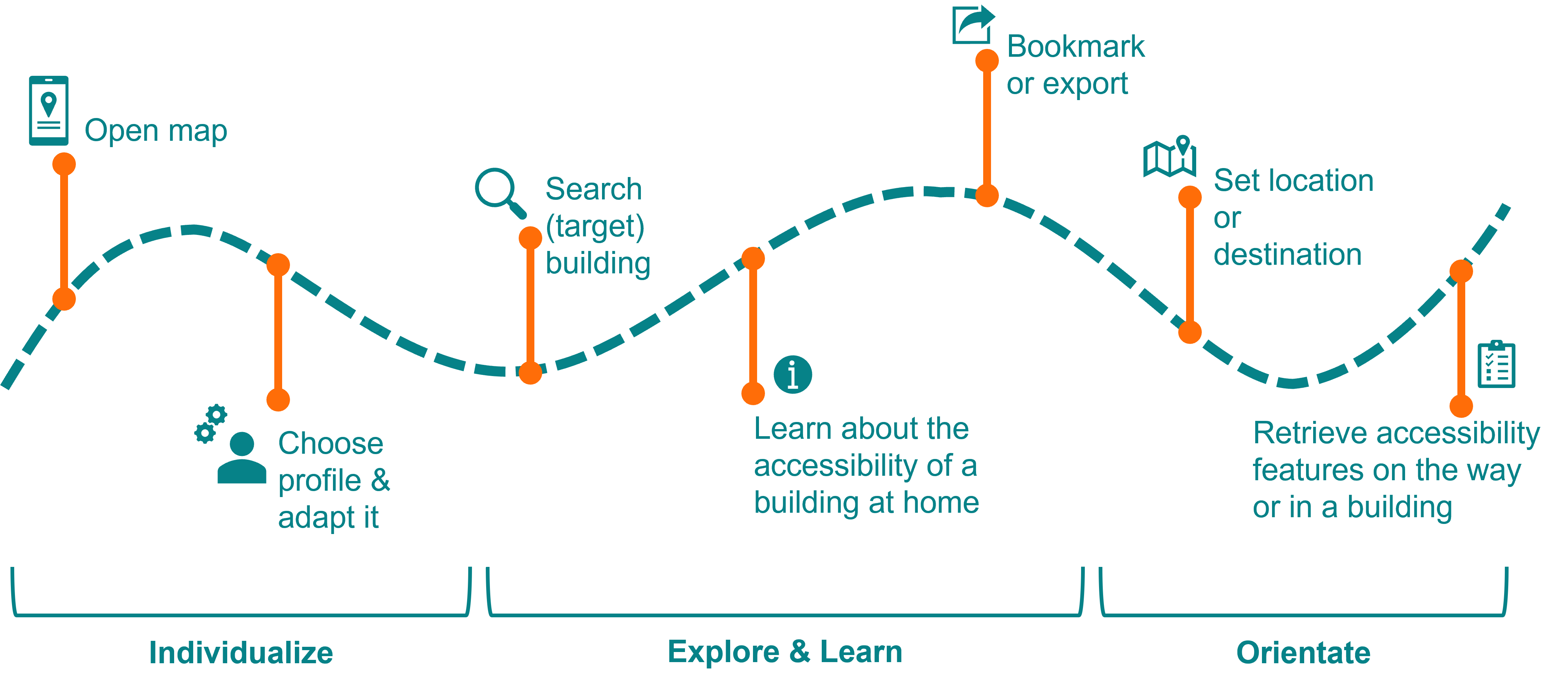
The diagram represents the possible interactions with the application on the basis of a path, represented by a wavy line. Along the line there are 7 vertical lines. At the end of each of these lines are the corresponding interactions. Each of these consists of a decorative symbol and a text. Below these line graphics are brackets with an opening to the top. Below each of the brackets is a label naming the a phase. The brackets group 2-3 of the interactions located above the line. The three phases, each with associated interactions, are: 1st phase: individualize; Interactions: Open map, choose profile & adapt it. 2nd phase: explore & learn; Interactions: Search (target) building, Learn about the accessibility of a building at home, Bookmark or export. 3rd phase: orientate; Interactions: Set location or destination, Retrieve accessibility features on the way or in a building
It consists of the following three phases. (1) adaption to your own needs and to the usage scenario (Individualize); (2) learning to use the application and explore the information provided about buildings from home (Explore & Learn); (3) Orientation with provided information inside a building (Orientate).
1st Phase – Individualize. In the first phase (individualization) the user firstly opens a map. That could be either a digital map in the application or a physical map such as a tactile print. A predefined profile can be chosen. The profile determines which accessibility information is displayed on the map. Further individual changes could be made to the profile. Additionally, the type of output could be chosen, e.g., visual, or tactile map, textual representation, and/or audio output. Finally, it is possible to specify whether use takes place at home or on-site (determines, for example, whether localization takes place).
2nd Phase – Explore & Learn. After the adaptation to the specific needs of the user, there is the phase of exploration and learning. A (target) building can be searched for e.g., by entering the address or the name of the building or visually on the map. Subsequently, the user can get information about the accessibility of a building at home. For this purpose, general information based on the selected customized profile about the building is displayed. The user can explore what is available in the specific building e.g., an elevator with the audio announcement and where it is located. In addition, it is possible to search for destinations or points of interest within a building. For later use, the map or building information can be saved or exported for printing or to share with others.
3rd Phase – Orientate. In addition to getting information from home, on-site orientation in a building is also important. For this purpose, the location and destination are determined. This makes it possible to find one’s own location within a building and, in a further step, to search for a destination on-site. The user is also able to search for information about locations of a certain class, e.g., all accessible toilets in a building. On the way to the destination defined in this way, for example, interesting places near the current location can be displayed or output. Therefore, information is provided in relation to the current location.