Participation at the AK GIS LKT Baden-Württemberg in Heidenheim
2023-06-15
On 20th April 2023, the 52nd meeting of the working group GIS of the Landkreistag Baden-Württemberg took place in Heidenheim. The event serves the exchange of the different districts of Baden-Württemberg in the field of geoinformation systems with regard to current problems and approaches to solutions. In addition to the pure exchange, there were also several presentations on various topics in the field, whereby the AccessibleMaps project participated with a presentation on the topic of “Accessibility in Maps”. In this presentation, solutions developed in the project were presented to the participants and possible fields of use of accessible map applications on the communal level were discussed.
Participation at FOSSGIS 2023
2023-06-15
At the current FOSSGIS 2023, on the one hand, project results were presented in the context of a lecture on the topic „Digitale Kartendaten für alle“. On the other hand, we participated in the expert meeting „Indoor OSM“ in order to exchange information with representatives of different fields of interest in this area, as well as to network with other mappers and developers interested in the topic.
Online Indoor Tagging Meeting 2023
2023-06-15
Following the Indoor OSM 2022 Working Meeting in Frankfurt am Main, an online meeting was held on February 14, 2023, to discuss the problems. The results of this meeting can be found under the following link:
https://wiki.openstreetmap.org/wiki/Indoor_Tagging_Meeting_2023-02-14
Indoor OSM 2022 Working Meeting
2023-06-15
From October 14 to 16, 2022, a working meeting on the topic of indoor mapping in OpenStreetMap took place in Frankfurt am Main. The event, which was supported by the FOSSGIS e.V. association, was aimed to the target group of mappers and developers who are active in the field of indoor mapping in OSM and was attended by two employees of the TU Dresden. The topic of the event was the adaptation and extension of the Simple Indoor Tagging format in OpenStreetMap, which is used to map buildings. In addition to the consideration of current problems from different perspectives such as 3D rendering or detection of barriers, solution proposals were developed and the further procedure for implementation and networking was discussed. A summary of the meeting can be found under the following link:
https://wiki.openstreetmap.org/wiki/Arbeitstreffen_Indoor_OSM_2022
Survey for the evaluation of object sounds (auditory icons)
14.11.2022
Dear prospective participants,
We would like to invite you to a survey that evaluates 40 auditory icons created by us. These are sounds for everyday “objects”, such as obstacles, stairs, people, bicycles or bathrooms. The study is primarily for people with blindness or mobility impairments, but we also encourage people without any disability to participate. Participation is open until November 30, 2022. It will take approximately one hour to complete the questionnaire. We would greatly appreciate it if you could pass the questionnaire on to people with blindness or mobility impairments in your circle of acquaintances.
You can find the survey at the following link:
https://soscisurvey.sport.kit.edu/AuditoryIcons/?q=Teil1
We thank you in advance for your participation. Your answers will be stored anonymously, treated confidentially and not passed on to third parties. The results will be used exclusively for scientific purposes. At the end of the survey you have the chance to win one of five Amazon vouchers worth 25€ each.
Presentation of Results at the LNdW and the Output
2022-08-03
The Long Night of Science in Dresden and the Output of the Faculty of Computer Science at the TU Dresden invite interested citizens to participate to current research results every year. This year, the opportunity was used to present the current results of the research project as part of a project showcase. The presented prototypes included the developed web application, which addresses people with visual and mobility impairments, tactile printed indoor maps and the possibility of displaying dynamic tactile maps on a pin-matrix device.
FOSSGIS 2022 Lecture and Panel of Experts
2022-08-03
As in the previous year, current results of the project were presented and discussed at FOSSGIS 2022. On the one hand, we explained options how to collect accessibility information in buildings as part of a lecture. On the other hand, there was a panel of experts on the subject of “accessible indoor maps”, which was used to discuss and exchange knowledge. A video of the lecture is available at https://media.ccc.de/v/fossgis2022-14136-erzeugung-von-indoor-karten-daten-unter-bercksichtigung-von-barrierefreiheitsinformationen.
AccessibleMaps at the ICCHP
AccessibleMaps is represented at this year’s ICCHP conference with eight scientific publications that have been produced as part of the project. The following papers are presented in the special thematic session “Digital solutions for inclusive mobility: solutions and accessible maps for indoor and outdoor mobility”.
- Split It Up: Allocentric Descriptions of Indoor Maps for People with Visual Impairment
- Expert Study: Design and Use of Textures for Tactile Indoor Maps with Varying Elevation Levels.
- Atim: Automated Generation of Interactive, Audio-Tactile Indoor Maps by Means of a Digital Pen.
- An Audio-Tactile System for Visually Impaired People to Explore Indoor Maps.
- Supporting Independent Travelling for People with Visual Impairments in Buildings by Harmonizing Maps on Embossed Paper and Pin-Matrix Devices for Accessible Info-Points.
- The Accessible Tactile Indoor Maps (Atim) Symbol Set: a Common Symbol Set for Different Printing Methods.
- Indoor Navigation Assistance for Visually Impaired People via Dynamic SLAM and Panoptic Segmentation with an Rgb-D Sensor.
- Accessible Adaptable Indoor Routing for People with Disabilities.
We are very pleased to present and discuss the diverse results from the project to an international community.
Comprehensive Study to Evaluate the Design of Tactile Indoor Maps
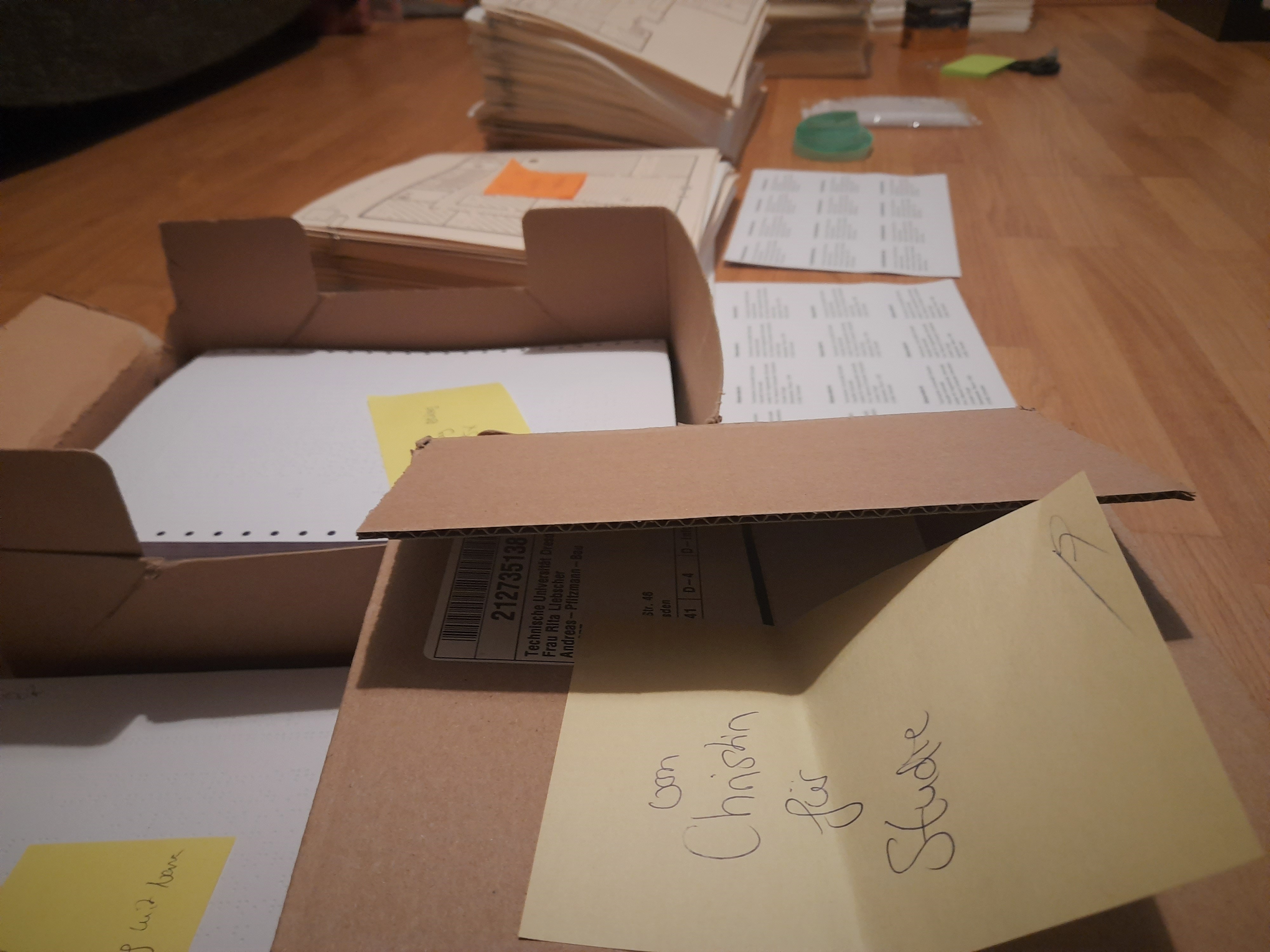
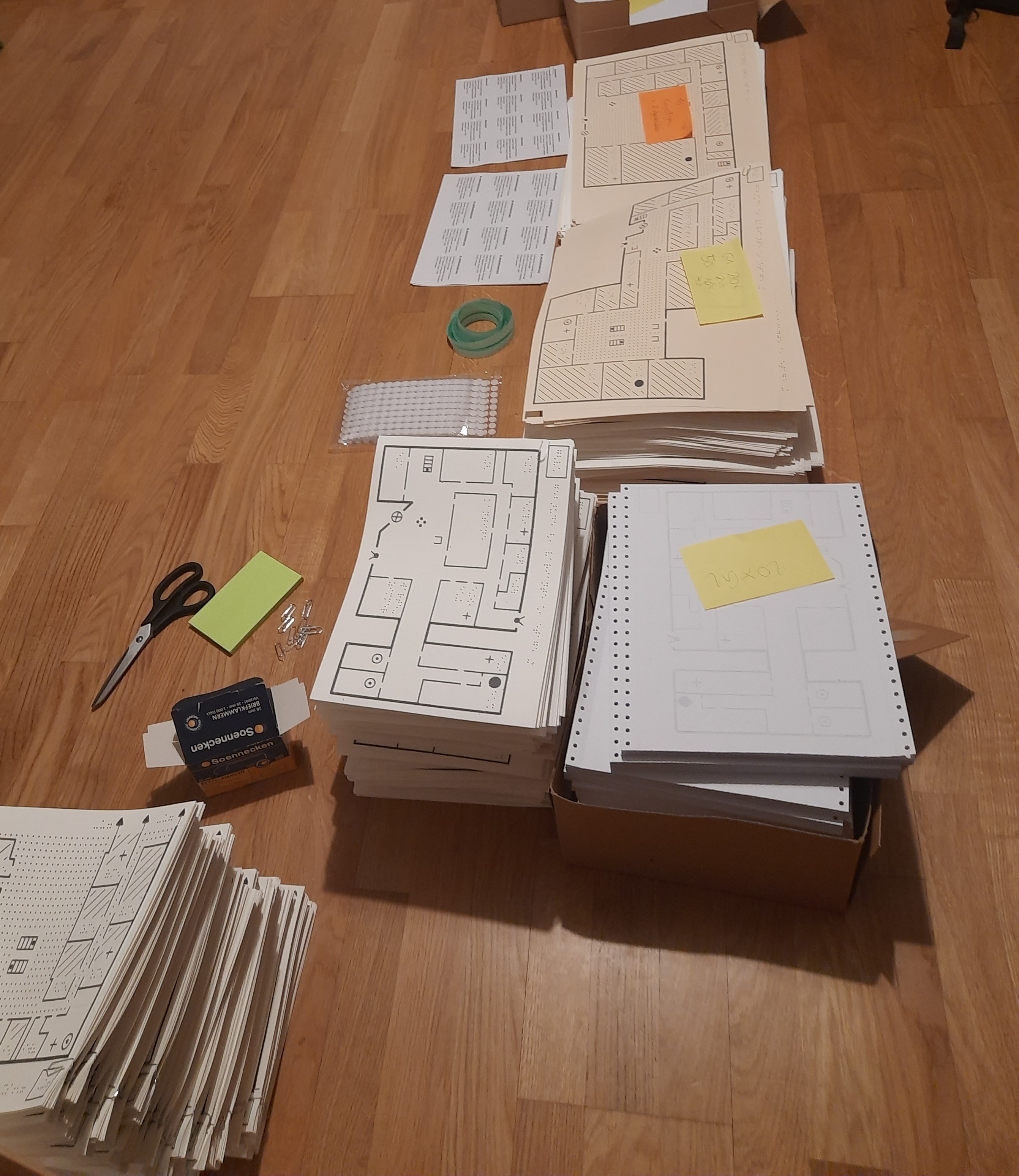
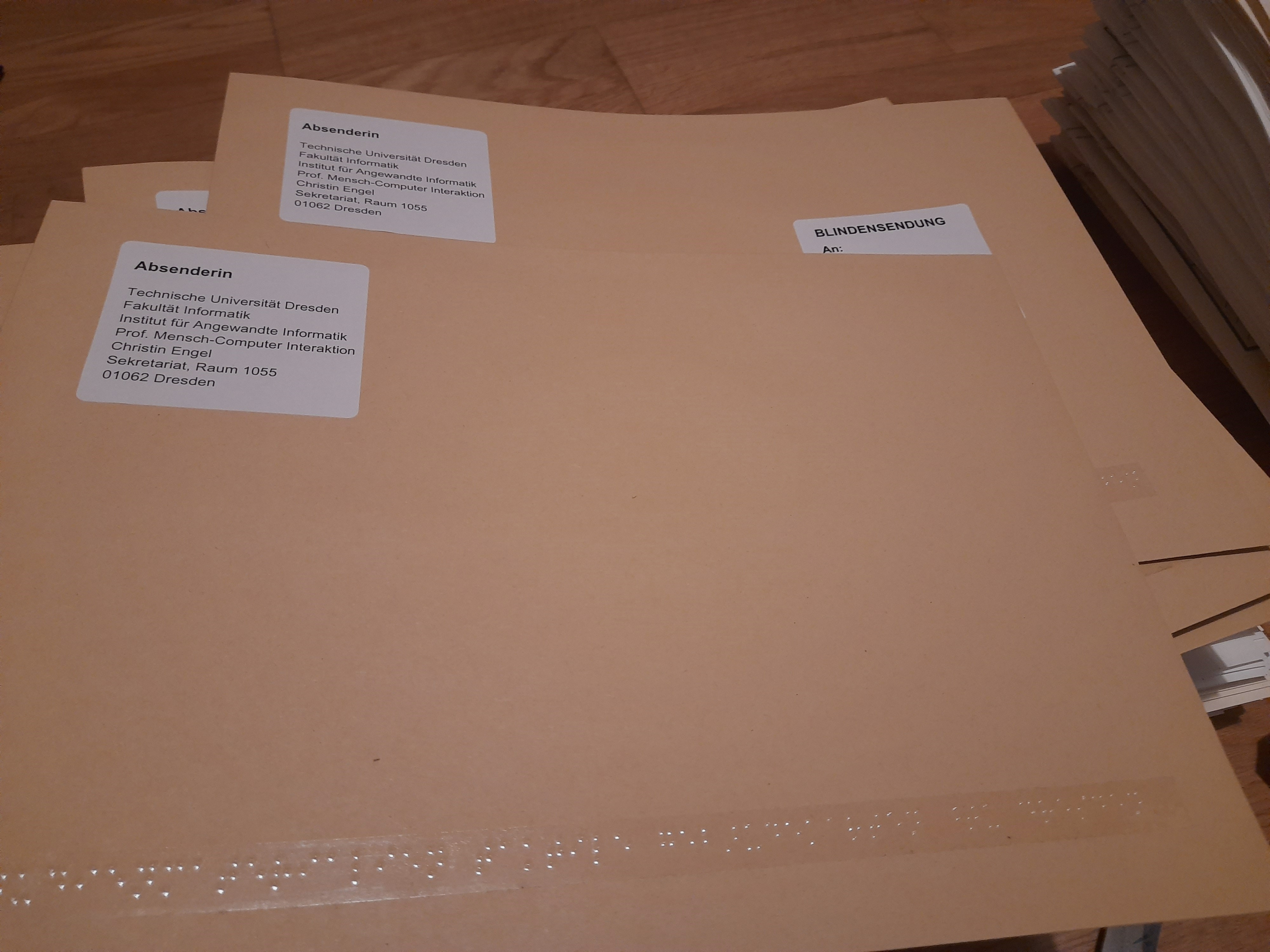
18.03.2022
A study on the evaluation of tactile indoor maps is currently taking place at the TU Dresden, for which more than 50 interested people with blindness or visual impairment have already registered. The participants receive tactile materials by mail, which they subsequently have to evaluate within an online questionnaire. Currently, the first envelopes are being mailed to participants. The results of this study will enable us to obtain a comprehensive picture of the design and use of tactile indoor maps on swell paper and in embossed printing.
Registration for participation in the study is still possible. If you are interested, please contact Christin Engel at christin.engel@tu-dresden.de

Special Thematic Session at ICCHP-AAATE 2022
19.01.2022
At this year’s ICCHP-AAATE international conference, we will have a special thematic session on digital solutions and accessible maps for indoor and outdoor mobility. Submissions for this special session have to follow the standard conference submission process. More information can be found on our page at the ICCHP-AAATE
Second Meeting of the Advisory Board of the AccessibleMaps Project
18.10.2021
The second meeting of the Advisory Board of the AccessibleMaps project was held on 01 October 2021. The meeting was attended by fifteen people from the advisory board and nine project staff. Also in the second year, due to the pandemic, the meeting was held virtually. This year the topic was the work of the second year of the project. Thereby, the two work priorities “From building plan to OSM maps” and “From OSM maps to users” were presented. The current status was shown on the basis of various demos. In a subsequent discussion, questions and suggestions were discussed together.
FOSSGIS 2021 Workshop
28.07.2021
Our workshop at the German conference FOSSGIS 2021 on the mapping of accessibility features using our created analysis tool is now online: https://media.ccc.de/v/fossgis2021-9022-analyse-tool-fr-simple-indoor-tagging-basierend-auf-osminedit
Questionaire report online now
18th May 2021
The report to the questionaire “Challenges for people with impairments in unfamiliar buildings” ist now online and available for download as an accessible PDF. Go to Report.
Project Results: Personas online now
9th February 2021
Results of the project should also be available for others to use. For this reason, they can now be accessed under “Results”. The personas developed there will give you a deeper insight into the target group addressed by the project. Go to the Project Results
Flyer of the project online now
3rd February 2021
The official flyers in postcard format and as leaflets of the research project AccessibleMaps are now online and available for download. Go to Project Info
New publication at the ASSETS conference 2020
20th October 2020
First virtual meeting of the Advisory Board of the AccessibleMaps project
7th October 2020
The first advisory board meeting took place on 7th October 2020. Representatives of local and national self-help organizations of people with visual and mobility impairments, representatives for professional participation as well as from the area of construction, building design and mapmaking were invited to join the advisory board. Fourteen guests and ten project collaborators took part in the meeting. Due to the current situation, the meeting was organized virtually. During the meeting, the project results of the first year were presented. In the subsequent discussion, the members of the advisory board had the opportunity to discuss the results of the project with the project staff and to network.
Maps for the Web
24th August 2020
As part of the workshop series Maps for the Web we will talk about our project and try to sensitize international working groups in the field of web-based maps to the topic of accessibility.
First advisory board meeting planned
24th August 2020
The first meeting of the advisory board will take place on 07th October 2020. A total of 23 participants have been invited. Among them are national and local stakeholders of the target groups, representatives of the labour, construction and planning sectors, as well as specialists from the field of mobility training.
Workshop at the MUC
24th August 2020
As part of the conference “Mensch und Computer 2020” Accessible Maps offers a workshop on “Digital solutions for more inclusive mobility”.
It will take place on Monday, 07.09.2020 and will be dedicated to equal opportunities for people with disabilities and chronic illnesses in education and in everyday working life by critically evaluating current measures to promote mobility, developing requirements for innovative digital solutions and showing new perspectives.
List of speakers:
- Accessible Indoor Maps
Karin Müller, Karlsruher Institut für Technologie
Claudia Loitsch, Technische Universität Dresden
- Linked Data for Accessibility
Sebastian Felix Zappe; Sozialhelden e.V.
Holger Dieterich; Sozialhelden e.V.
- ASSIST ALL: Virtueller Assistent zur Orientierung in Innenräumen für Menschen mit Behinderung
Johannes Britsch; contagt GmbH
- DYNAMIK – eine bedürfnisorientierte Navigationsapp
Verena Traubinger M. Sc.; Technische Universität Chemnitz
- Entwicklung einer barrierefreien Straßenkarte mittels Machine Learning und Crowd Sourcing
Janick Edinger; University of Mannheim
- Navigation mit Hindernissen
Benjamin Tannert, Bremen Spatial Cognition Center (BSCC)
Accessible Maps and OpenStreetMap
24th August 2020
Accessible Maps uses OpenStreetMap (OSM) for collecting, structuring and issuing indoor maps. You can find out more about the use of OSM for Accessible Maps on our OSM Wiki page.